
 |
| HARBORMASTER |
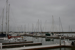


This area is zoned "Tidal Plain" which specifically supports marina and boatyard activities. Westpoint Harbor is consistent with the region. It is also in the Port of Redwood City's "sphere of influence" and consistent with the San Francisco Bay Area Seaport Plan" as prepared by the Metropolitan Transportation Commission and Bay Conservation and Development Commission (BCDC)


This project is compatible and beneficial for Cargill salt activities. The adjacent salt operation area is a "bitten pond," and the Westpoint Harbor provides a buffer between Westpoint Slough and the ponds, particularly the weather-exposed northern boundary.
Westpoint Harbor was conceived as an "inland project". It does not extend into navigable waters at all, so there are no dredge materials to get rid off. The site was planned so that the boat basin produced just enough material for the upland portions of the Marina. The marina provides access and adds to Bay surface and water volume.


Westpoint Marina is near Greco Island, a wonderful wildlife refuge sheltering an array of wildlife, including some endangered species. One of the facets of Westpoint Marina is to provide walkways, viewing areas, and benches so people can see, but not travel to Greco Island. It took 12 years to assemble the permits required, there was no opposition to the project.


No comments:
Post a Comment